
Walk This Way
Safer Pathways for OBX Pedestrians
By Jes Gray
100 years ago, those that explored the Outer Banks did so via unpaved paths negotiated by machine or beast, or simply by foot. Folks were more likely to travel to and from their homes by water, and the tourism that did exist was catered to in that manner (or occasionally by air- how fancy!). Small family crafts crisscrossed the sounds, larger boats brought the well-appointed wealthy, and sardine packed ferries carried over walk-ons.

In the 1930s that all changed however, when the Wright Memorial Bridge crossed the Currituck Sound to Kitty Hawk and the Washington Baum Bridge joined Roanoke Island to Nags Head. Paved roads soon followed up and down what’s now known as The Outer Banks. As the public discovered the beauty and abundance, local residential populations grew, and those roads went from non-existent to crowded in less than a century.
Just as these changes didn’t happen overnight, the public response to issues caused by the increased traffic and pedestrians is still playing catch up. Much effort has been put into the Route 12, aka “The Beach Road,” area where tourists have historically reigned, but the “West Side” or “Sound Side” where most year round residents live has been largely ignored, outside of the scenic sound front areas.
That is beginning to change though, as four miles of new pathways in Kitty Hawk, targeted sidewalk expansions in Kill Devil Hills, and an ambitious half-mile long boardwalk in Nags Head are being built to address these long-standing concerns about pedestrian safety amid traffic and development. Funded through a mix of state grants, local tourism taxes, and municipal budgets, they reflect a broader commitment to sustainable growth in a remote region where rapid growth has led to rapid change.
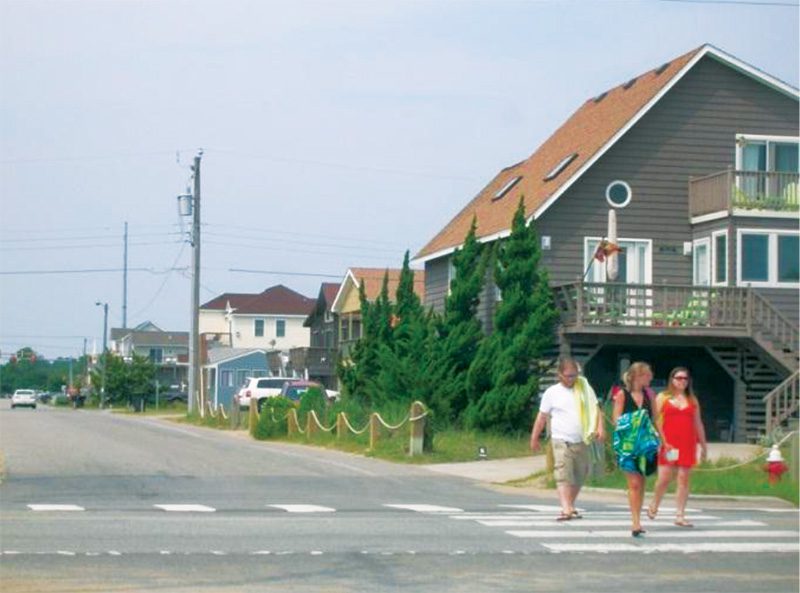
Walking is popular throughout Kill Devil Hills by residents and visitors. Courtesy of KDH Pedestrian Plan.
KITTY HAWK
Locals and visitors alike in Kitty Hawk are aware of the perils of its main artery, US Highway 158 aka “The Bypass.” This bustling corridor sees speeds topping 50 mph even during peak summer months, leaving pedestrians, who often walk to beaches, shops, or soundside parks. vulnerable to close calls with vehicles. With Dare county moving up the ratings for vehicle crashes each year from 2017-2021, government officials, politicians and local stakeholders pursued further pedestrian options. Through the North Carolina Department of Transportation (NCDOT) a multi-mile sidewalk project designed to create a dedicated pedestrian haven on the highway’s west side, or soundside began this past fall.
Approved in January 2025, but on the agenda for over a decade, the initiative targets high-traffic areas with sparse development, where walking has historically been risky and impractical. The sidewalk will stretch nearly four miles, providing a continuous path that links residential zones, local businesses, and recreational sites. Construction was slated to break ground this past fall, with completion eyed for late 2026, weather permitting. While exact costs remain under wraps pending final bids, the project is jointly funded by the Town of Kitty Hawk and NCDOT, bolstered by a grant from the Outer Banks Visitors Bureau.
The design incorporates ADA-compliant ramps, wide berths for cyclists, and subtle lighting to encourage evening strolls, all while blending into the landscape with native plants. According to the NCDOT, “This Project consists of …a sidewalk on the west side of US 158 in Kitty Hawk from Cypress Knee Lane to Jejac Street. The Municipality is responsible for 20% of the actual costs of the Project…for a total of $1,040,000. The new total estimated cost of the Project is $7,200,000.” Pricey? Yes, but a small cost to pay if it saves lives, right?
KILL DEVIL HILLS
Less visible but no less vital, a series of sidewalks are spreading through the rapidly expanding west side neighborhoods of Kill Devil Hills, dramatically changing the pedestrian landscape—and also a lot of folks’ driveways and yards. By November 2025, several key segments were under construction, focusing on West Martin Street, Swan Street, and East Baum Street, as part of a broader $2.3 million infrastructure overhaul.
The West Martin Street multiuse path project, which began in September 2025, involves road widening from Blue Jay Street to US 158, complete with new sidewalk installation. Stormwater pipes have recently been put in place from Ninth Avenue to Seventh Avenue, with ongoing work between Sixth and Swan Streets as of late November ‘25. The process is not simple as water mains needed upgrades and fire hydrants replaced, along with the many trees and roots that needed to be removed. A spring 2026 finish is targeted.
These expansions link fragmented sidewalk sections, creating safer access to the Parks & Recreation Center, Baum Center, and Wright Brothers Memorial—vital for families, students, and tourists navigating the town’s residential areas. Funding comes from a complex blend of sources, including a $240,000 Tourism Impact Grant approved in January 2025, part of a $1.16 million county-wide package, underscoring how tourism (generating over $1 billion annually for Dare County) funds improvements that mitigate its own pressures, like overcrowded roads and strained pedestrian routes.
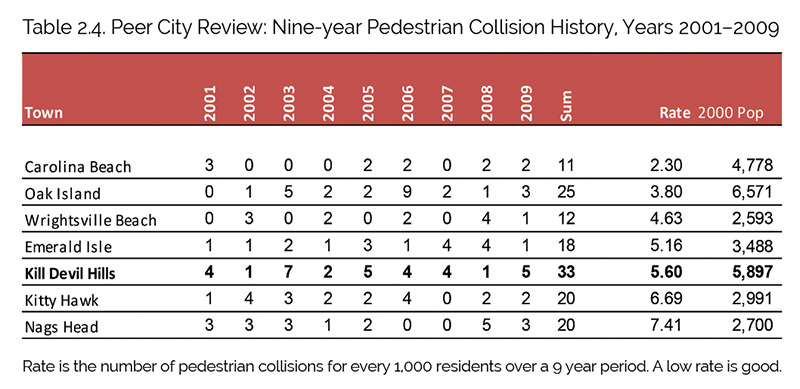
Worn path shows pedestrian demand along US 158 despite the lack of a sidewalk. Table 2.4 and image courtesy of KDH Pedestrian Plan.
NAGS HEAD
Further south in Nags Head, the focus shifts from managing safe walking paths to featuring the sometimes overlooked (pun intended) Roanoke Sound. The Soundside Event Site boardwalk, a $3.3 million dollar investment in a non-beach focused attraction, was approved by Dare County commissioners in September 2025. Roughly a half-mile long and 8-feet-wide, this concrete pathway will feature a pergola, seven boat slips, a 2,000-square-foot gazebo, and educational placards.
Planners hope to transform this 20-acre public site into a nature-centric destination. It’s the start of an overall design that could culminate in an indoor sports and events arena. Funded entirely by the Outer Banks Visitors Bureau’s designated tourism taxes taken from occupancy and meals taxes, the project sidesteps general taxpayer dollars, echoing past investments like the Duck Soundside Boardwalk. Construction kicked off shortly after approval, with a 150-day timeline aiming for spring 2026, though coastal variables could push it later.
The design preserves open-water activities: kiteboarding, stand up paddle boarding, sailing, etc, while adding shaded access points along the walkway. Nags Head’s Board of Commissioners is already eyeing extensions, proposing a contiguous boardwalk linking the site to the Outlets Nags Head shopping center. Discussed in September meetings, this vision includes multi-use paths lined with shade trees, blending recreation with retail, dining, and soundside views. Ultimately many more pedestrian and bicycle friendly pathways are envisioned, encompassing Whalebone Junction, Jennette’s Pier, and beyond.
Economically, it could amplify the site’s event potential, from music events, car shows, and markets, while environmentally, permeable designs and native plants safeguard wetlands. As the project progresses, the goal of preserving public access is also intertwined, envisioning increased opportunities to enjoy the sound for longtime communities and visitors alike.
COMMUNITY CONNECTOR
These interconnected projects in Kitty Hawk, Kill Devil Hills, and Nags Head have goals higher than sidewalk level. The community leaders hope they are stitching together a safer, more inviting Outer Banks. By giving residents and visitors continuous, car-free routes to beaches, shops, parks, and the sounds, the towns are dramatically improving everyday access for families, seasonal workers, seniors, and cyclists alike.

Author: Jes Gray
