
Into the Deep: Shipwrecks That Shaped Our Coast
The history of the Outer Banks can be told many ways, from the stories of free spirits and explorers to shifting sand dunes and fishing seasons. It can be seen in the weathered cottages in south Nags Head, the fuzzy winter coats of the Corolla ponies, and even the traffic that backs up on Highway 12 on summer Saturdays. The history of the Outer Banks is quite literally the stuff legends are made of, and perhaps nothing is more legendary than the Graveyard of the Atlantic.
The waters off North Carolina are known as the Graveyard of the Atlantic due to the shipwrecks that dot the coastline – they number in the thousands. Strong currents, irregularly-shaped barrier islands, and constantly shifting sands make it extremely difficult for ships to navigate the area, even with modern technology. Where the water is deep one day it may become shallow the next. Inlets and shoals form and disappear with the weather and the pull of the moon. Some of the most experienced crews found themselves run aground when they thought they were much further out at sea.


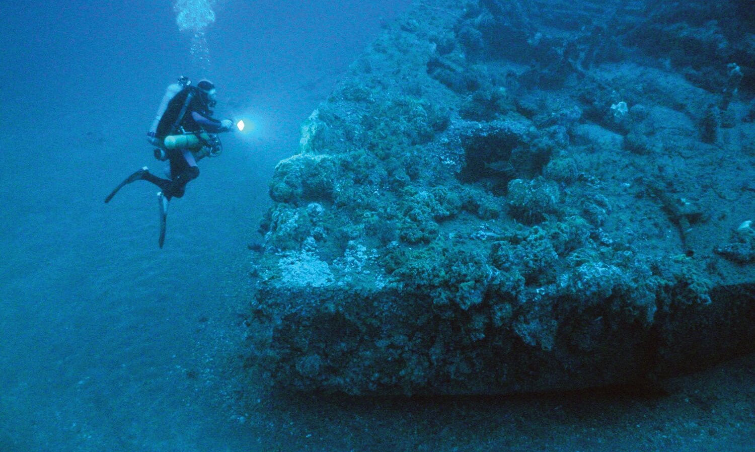
Wreck of the German U-576 off of Cape Hatteras. Photo courtesy NOAA
And this is where the history of the Banks merges with the history of the sea that shaped them. In the early days, before there were lighthouses and rescue crews, these grounded ships were at the mercy of the people who lived on the island. Word of a “ship on the beach” would bring everyone out to salvage the wreck for anything useful or valuable. It’s well-known that many of the original homes on the island were constructed with wood taken from shipwrecks – you could say that the history of the Graveyard of the Atlantic is built right into our daily lives.
These wrecks brought people to the Outer Banks too. Some were shipwrecked and stayed, and others migrated here via the Lifesaving Service. Presently, the wrecks attract tourists and researchers who contribute to both the local economy and to the canon of our local history.
USS Huron & Metropolis

USS Huron in port at Newport News, VA, July 1919. Photo courtesy U.S. Navy
Two wrecks, one off of Nags Head in 1877 and the other off Corolla in 1888, resulted in the beginnings of the United States Coast Guard as we know it today.
The USS Huron’s final resting place is about 250 yards offshore, just north of the Nags Head Fishing Pier between mileposts 11 and 12. On November 24, 1877 the ship ran aground during a storm. While it wasn’t too far offshore, the crew were unable to swim to safety due to the severe impact the weather was having on the surf. The lifesaving stations were closed until December, so no help came for the crew of the Huron and 98 men died as a result.
Just a few weeks later, in January, the Metropolis was bound for Brazil with over 200 men aboard when she hit the shoals just off of what is present-day Corolla, near Albacore Street. Ironically, the Metropolis had previously seen action during the Battle of Roanoke Island. After the Civil War the ship was sold and not refitted properly, which played a large  role in her sinking. Eighty five people died in the wreck.
These two tragedies prompted Congress to authorize both the construction of new lifesaving stations and acted as a catalyst of change to usher in a new era of lifesaving on both the Outer Banks and up and down the East Coast.
Both wrecks are on the National Registry of Historic Places and parts of them can sometimes still be seen from the shore. The USS Huron was the first dedicated Historic Shipwreck Preserve. Recreational diving is allowed, but disturbing the wrecks or collecting any artifacts is not. Designating these sites as historic places allows officials to preserve the wrecks, promote public education and awareness, and keep them accessible to the public.
USS Monitor
The story of the Monitor is steeped in history, legend, and controversy. The impact the wreck has had on the development of regulations on underwater archeology, recreational diving, promoting cultural history, and the preservation of wreck sites reaches far and wide.
The USS Monitor site was the first to be designated as a Marine Sanctuary and set the stage for expanding protection of other historic wrecks across the country.
Researchers from Duke University located the wreck of the Monitor in 1973 and the site was quickly nominated for National Marine Sanctuary status by the governor of North Carolina. On January 30, 1974 President Ford approved the designation, making the Monitor site the first National Marine Sanctuary. Since then, over 170,000 square miles of waters have been put under the protection of the act – this includes 13 sanctuaries with sites in the Great Lakes, Hawaii, the Florida Keys, Monterey Bay, and more.
The bow of the USS Monitor. Photo courtesy NOAA
Unlike many Outer Banks wrecks, Monitor cannot be seen from the shore, nor is it easy to get to. The ship’s final resting place is about 16 miles off Cape Hatteras, more than 200ft below the surface. This is right where the cold Labrador Current and the warm Gulf Stream converge, making it extremely difficult and dangerous to access the wreck. The unstable environment also makes preserving the wreck site challenging.
In addition to this (and like many other Outer Banks shipwrecks), the wreck of the Monitor is a gravesite. In 2013 the recovered remains of two sailors were laid to rest at Arlington National Cemetery, but 14 other sailors died when the ship sank and their bodies were never recovered.
German U-boat 576 & Bluefields
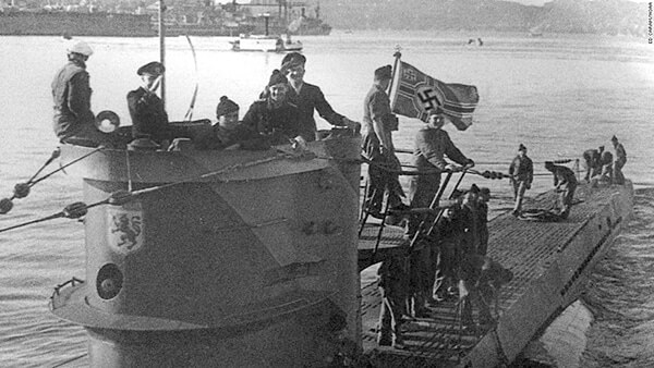
Crew members aboard the Nazi German U-576. Photo courtesy NOAA
Many people don’t realize how close WWII came to the East Coast of the United States. During the war, German U-boats (submarines) lurked in the waters off of the Outer Banks, attacking freighters that were transporting supplies, oil, and troops to the European theater. Many of these ships were also carrying civilian passengers; people who ended up casualties of war in American waters.
The attacks were so widespread and damaging that news of them was kept classified in the interest of public safety. But they couldn’t be kept a secret from the people living on the Outer Banks. Explosions that rocked the island were a common occurrence, as was debris washing up on shore and massive oil spills that polluted the water.
The freighter Bluefields was heading south with supplies when it was attacked and sunk by U-576 in July 1942. In response, the Navy launched a counter-attack that ultimately led to the sinking of the sub. The vessels now rest just over 200 yards apart and tell the story of an important part of history that has been widely overlooked for the last 70 years. They also demonstrate a partnership between two federal agencies, NOAA and the Bureau of Ocean Energy Management, which is a significant development in the ever-evolving quest to document and preserve these significant sites.
There are dozens of WWII-era wrecks in the water right off our barrier islands, however the only dedicated sanctuary is the Monitor site.
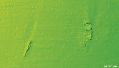
Multibeam sonar scanned image of U-576 and Bluefields and their proximaty to one another.
While it’s illegal to disturb or salvage any of the wrecks, protection via inclusion in the Monitor National Marine Sanctuary would increase funding for research, exploration, and the development of public programming that would seek to increase awareness and appreciation of the Outer Banks’ unique cultural history.
These well-known wrecks serve as good representations of what’s out there; the thousands of ships, from freighters to military vessels, U-boats, trawlers, and recreational vessels that tell the maritime history of the Outer Banks. Many of them have not been mapped or documented and they are quickly succumbing to the rough Atlantic currents. The wrecks have also become an important part of the ecosystem, serving as reefs for a large variety of marine life. And while they are already somewhat protected from being salvaged, inclusion in an expanded marine sanctuary would assure that these wrecks are not only preserved, but included in mapping surveys as well as expanded public history programming and funding.
Outer Bankers know that nothing on this beach is permanent. A shift of the wind or a strong tide can reshape the way the coast looks, bury roads, and wash away houses. And much like the tides, the way we protect and preserve the history of our home is ever-changing.
NOAA is currently exploring ways to expand the marine sanctuary to include a significant number of historic wrecks, while at the same time maintaining a level of public access that would not disrupt commerce and recreation in area waters. For more information about the proposed expansion and the impact it would have on the Outer Banks community, visit: monitor.noaa.gov/management/expansion.html. ♦
Meg Puckett is a writer, social media specialist, and editor for Three Dog Ink Media. She once had the chance to walk around inside the Monitor’s turret, which was as close to a religious experience as she’ll ever get.

Author: Meg Puckett

